Guide to the location and navigation of the digitised images on the FamilySearch (LDS) website.
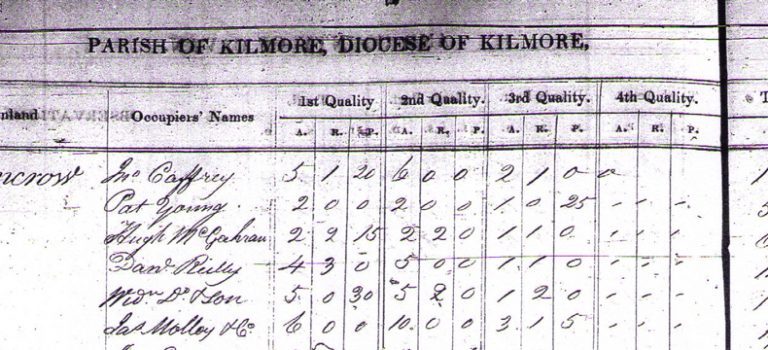
The lists of tenant names which we provide on this website have been scraped from the National Archives website. Unfortunately the indexation and classification of the records for this particular dataset on the NAI site are notoriously misleading and incorrect on a number of levels. Prior to the mapping of the country by the Ordnance Survey (Cavan was first mapped over the years 1835-1836) there was no standardised and approved list of townland names. Even a slight variation in spelling will turn up a negative result and a significant number of townland names were either transcribed incorrectly or the names do not match the approved accepted version. We suspect about 75% of the records are concealed due to these errors. What we present in our tables is a listing of tenant names which we have re-indexed by parish and townland. We believe this is correct to about 95% accuracy for townlands which were surveyed. Note the parish of Drung has not been transcribed and is missing from this dataset. We have not checked each individual surname entry and the only way to ensure accuracy is to view the original photographed TAB pages which can be viewed on the FamilySearch website. Access here requires signing up for an account but this is free. These images also provide details on the tenants landholdings and the taxation valuations which were applied to each plot.
It should also be pointed out that, although it only applies to a few parishes, some of the records are duplicated or triplicated as the survey was updated every few years. These books, which were typically an exact copy of the previous year, ended up being transcribed and added to the collection. Thus in the parish of Annagelliff you will find entries for four years, although this is an exception. In some instances the same individual has been given an alternate spelling of surname so checking the original photographs is crucial in avoiding errors. In rare instances we have found changes in leaseholder due to death or other cause and this can be a very interesting find for the genealogical fraternity.
The table below provides an index to the images of the original TAB which can be viewed on the LDS FamilySearch website. Searching directly by Cavan on this website results in the same flawed outcome achieved using the NAI site but the list below which we have prepared will guide the uninitiated to the core images which represent the true archive which is available, albeit well concealed. You will find some entries indexed under counties Meath, Down, Cork, Fermanagh, Leitrim and Mayo so the limitations are obvious. Also, a number of parishes have been grouped into one record and these are listed below. The FamilySearch website is the best place to view the images as the search facility by image on the NAI site is very cumbersome and limited to pdf files only. The FamilySearch website provides thumbnail images of the original pages as photographed and these are relatively easy to navigate with the index provided in the table which we have summarised below:
| Parish | Listed in County | Years listed | Records on image nos. | Index on Page No. |
|---|---|---|---|---|
| Annagelliff | Cavan | 1826/8/9/35 | Mixed | 7 |
| Annagh | Cavan | 1824/5 | All 182 | 148 |
| Bailieborough | Meath | Mixed | 3,30 | |
| Ballintemple | Cavan | 1825/8 | 14977 | 40 |
| Ballymachugh | Cavan | 1824 | All 13 | 9 |
| Castlerahan | Cavan | 1831 | All 100 | 81-84 |
| Castleterra | Cavan | 1826 | All 35 | |
| Crosserlough | Cavan | 1828 | All 43 | 34-36 |
| Denn | Cavan | 1827 | All 38 | 29-30 |
| Drumgoon* (see Drumgooland) | Down | 1833 +2 | Mixed 52-213 | 53,117, 184 |
| Drumlane* (see Drumgoon) | Cavan | 1828/29 | 8-97 of 142 total images | |
| Drumlumman | Cavan | 1824 | All 24 | 16 |
| Drumreilly | Leitrim | 1833 | Mixed | |
| Drung | Missing | |||
| Enniskeen | Meath | 1827 | 38-100 of 140 | 136 |
| Kilbride/Castlecor | Meath | 1825 | 43952 | 5 |
| Kildallan | Meath | 1835 | All 77 | 65-68 |
| Kildrumsherdan/ Killsherdeny | Cavan | 1832/33 +1 | All 119 | 49-51, 60,101 |
| Killashandra | Cavan | 1832 | All 70 | 4-7 |
| Killinagh | Cavan | 1833 | All 39 | No |
| Killinkere | Cavan | 1833 | All (mixed) | No |
| Kilmore | Mayo | 1831 | 13547 | |
| Kinawley | Fermanagh/Cavan | 1825 | Index only | 8-26 |
| Knockbride | Cavan | 1827 | All 40 | 32-33 |
| Larah | Cavan | 1833/34 +2 | All | |
| Lavey | Cavan | 1833 | All 74 | |
| Loughan/ Castlekeeran | Castlekyran, Co. Cork | 1829 | All 22 | 20 |
| Lurgan | Cavan | 1824 | 41640 (map 21) | 3-4 |
| Moybolgue* (see Bailieborough) | Meath | 1834 | 54-91 | 89 |
| Mullagh* (see Killinkere) | Cavan | 1833 | All (mixed) | No |
| Munterconnaught* (see Lurgan) | Cavan | 1824 | 15-18 | 15 |
| Scrabby | Cavan | ? | All 13 | 11 |
| Shercock | Cavan | 1825 | All 25 | 15 |
| Templeport | Cavan | 1825 +1 | All 412 | 189, 400 |
| Tomregan | Fermanagh | 1827 | All 47 | |
| Urney* (see Annagelliff also: 95-108. Index 81) | Cavan | 1828 | All 27 | 24 |
Related Articles
